Table of Contents (16 sections)
In recent years, the use of drones in disaster management has gained significant traction. These unmanned aerial vehicles (UAVs) have proven to be invaluable tools for various disaster response operations. As natural disasters become more frequent due to climate change, the need for efficient and effective disaster management solutions increases. Drones offer unique capabilities that enhance situational awareness, aid in search and rescue missions, and facilitate the delivery of essential supplies. This article delves into how drones are revolutionizing disaster response efforts and the benefits they bring to emergency management.
Information on Drones in Disaster Management
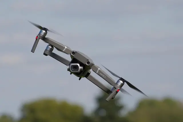
Drones refer to aircraft that can fly without a human pilot onboard, controlled either autonomously by onboard computers or under the remote control of a user. In the context of disaster management, they are deployed to perform a variety of tasks:
- Surveillance and reconnaissance
- Aerial imagery and mapping
- Cargo transport
- Disaster victim locating
- Environmental monitoring
The utility of drones in emergency situations stems from their ability to access areas that may be dangerous or difficult for human personnel. For instance, after a hurricane, drones can survey damaged infrastructure, providing critical data to first responders. According to a report from the National Oceanic and Atmospheric Administration (NOAA), drone usage in disaster scenarios has increased by over 75% in the last five years. This rise emphasizes the growing recognition of their capabilities and the benefits they offer to disaster management agencies around the globe.
Procedures for Implementing Drones in Disaster Management
To effectively utilize drones in a disaster management operation, agencies must follow a series of steps aimed at ensuring safety and efficiency:
Step 1: Assessment of the Situation
Before deploying drones, it is crucial to assess the specific needs of the disaster area. This involves analyzing the type of disaster, affected population, and potential risks.
Step 2: Training Personnel
Personnel involved in operating drones must receive appropriate training. This includes understanding flight operations, safety protocols, and data analysis.
Step 3: Select Appropriate Drone Technology
Agencies should choose drones equipped with the necessary technology, such as high-resolution cameras, thermal imaging, and real-time data transmission capabilities.
Step 4: Coordination with Emergency Services
Collaboration with local emergency services ensures that drone operations complement ground efforts. Effective communication is key to maximizing the efficiency of both human and drone responders.
Step 5: Deployment and Data Gathering
Drones should be deployed to gather data such as aerial images, thermal scans, and geographical maps. This information is vital for informed decision-making during emergency response.

startech cable management spine-cable organizer-flexible & adjustable noir
Darty FR


Répartiteur vidéo HDMI 2.0 4K 60Hz type splitter qui duplique à l'identique 1 source en entrée vers 4 sorties simultanées. Support CEC et management
Darty FR
Comparative Analysis of Drone Technologies
To understand which drones are best suited for disaster management, the following table compares several popular drone types used in emergency situations:
| Drone Model | Flight Time | Payload Capacity | Camera Quality | Best Use Case |
|---|---|---|---|---|
| Model A | 30 minutes | 5 kg | 4K | Surveillance |
| Model B | 20 minutes | 2 kg | HD | Mapping |
| Model C | 40 minutes | 10 kg | 8K | Cargo transport |
| Model D | 25 minutes | 3 kg | Thermal | Search & rescue |
Statistical Insights into Drones in Disaster Management
Recent studies highlight the increasing effectiveness of drones in disaster management. According to the Federal Emergency Management Agency (FEMA), utilizing drones has improved response times to natural disasters by up to 40%. The data reveals that drone technology enhances operational efficiency, allowing agencies to use resources more effectively. For example, drones can cover large areas in a fraction of the time it would take ground teams, allowing for quicker assessments and interventions.
Expert Opinions on Drones in Disaster Management
> 💡 Expert Insight: According to Dr. Emily Fisher, a noted researcher in drone technology and disaster management, "Drones enable us to survey disaster-hit areas faster and safer than ever before. Their aerial perspective allows us to identify critical needs promptly, ultimately saving lives and resources."
📺 Resource Video
For further exploration: [The Role of Drones in Disaster Management], a comprehensive overview of drone technology's impact in crisis situations. Search on YouTube: "drones in disaster management 2026".
FAQs about Drones in Disaster Management
- What types of disasters can drones help manage?
Drones are effective in managing various disasters, including wildfires, floods, hurricanes, and earthquakes. They provide real-time data and situational awareness.
- Are drones safe to use in disaster areas?
Yes, with proper training and adherence to safety protocols, drones can operate safely in disaster zones, helping to reduce risks to human responders.
- How do drones improve response time in emergencies?
Drones can quickly survey large areas, allowing emergency services to identify needs and allocate resources more efficiently than traditional methods.
- Can drones deliver supplies during a disaster?
Absolutely! Many drones are equipped to carry and deliver essential supplies, making them invaluable for reaching isolated communities after disasters.
Glossary
| Term | Definition |
|---|---|
| Drone | An unmanned aerial vehicle controlled autonomously or remotely. |
| Payload | The cargo that a drone can carry, often measured in kilograms. |
| Thermal Imaging | A technology that uses infrared sensors to detect heat signatures, useful for locating individuals or assessing damage. |
Checklist before deploying drones in disaster management
- [ ] Assess the disaster situation thoroughly
- [ ] Train drone operators effectively
- [ ] Choose the appropriate technology for the task
- [ ] Coordinate with local emergency services
- [ ] Gather data and analyze it efficiently
Conclusion
As we delve deeper into 2026, the integration of drones in disaster management continues to redefine emergency response approaches. By leveraging advanced technologies, agencies can not only react to disasters more efficiently but also prepare better for future emergencies. Understanding and adopting drone technology could potentially save countless lives and significantly improve recovery outcomes. For those interested in harnessing the power of drones, we have curated several products that can enhance your operational capabilities.
Explore our recommendations below!
📺 Pour aller plus loin : drones in disaster management 2026 sur YouTube
Recommended products
Selected by our experts
startech cable management spine-cable organizer-flexible & adjustable noir
Darty FR
This product can help organize and manage drone cables, ensuring a smooth operation during critical missions.
Think Tank Photo Cable Management 10
thinktankphoto.com
A durable management system is essential for keeping all electrical connections secure and efficient in the field.
Répartiteur vidéo HDMI 2.0 4K 60Hz type splitter qui duplique à l'identique 1 source en entrée vers 4 sorties simultanées. Support CEC et management
Darty FR
A reliable video splitter can ensure that all visuals from the drone are transmitted clearly for assessment and decision-making.